الاسم
ST_Grayscale — تُنشئ رسترًا جديدًا بنطاق 8BUI واحد من الرستر المصدر والنطاقات المحددة التي تمثل الأحمر والأخضر والأزرق
المختصر
(1) raster ST_Grayscale(raster rast, integer redband=1, integer greenband=2, integer blueband=3, text extenttype=INTERSECTION);
(2) raster ST_Grayscale(rastbandarg[] rastbandargset, text extenttype=INTERSECTION);
الوصف
تُنشئ رسترًا بنطاق 8BUI واحد انطلاقًا من ثلاثة نطاقات مُدخلة (من رستر واحد أو أكثر). أي نطاق مُدخل لا يكون نوع بكسلاته 8BUI سيُعاد تصنيفه باستخدام ST_Reclass.
![[ملاحظة]](../images/note.png)
|
|
|
لا تشبه هذه الدالة ST_ColorMap مع الكلمة المفتاحية |
متاحة منذ: 2.5.0
أمثلة: الصيغة 1
SET postgis.gdal_enabled_drivers = 'ENABLE_ALL';
SET postgis.enable_outdb_rasters = True;

WITH apple AS (
    SELECT ST_AddBand(
        ST_MakeEmptyRaster(350, 246, 0, 0, 1, -1, 0, 0, 0),
        '/tmp/apple.png'::text,
        NULL::int[]
    ) AS rast
)
SELECT
    ST_AsPNG(rast) AS original_png,
    ST_AsPNG(ST_Grayscale(rast)) AS grayscale_png
FROM apple;
|
 original_png
|
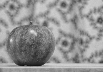 grayscale_png
|
أمثلة: الصيغة 2
SET postgis.gdal_enabled_drivers = 'ENABLE_ALL';
SET postgis.enable_outdb_rasters = True;

WITH apple AS (
    SELECT ST_AddBand(
        ST_MakeEmptyRaster(350, 246, 0, 0, 1, -1, 0, 0, 0),
        '/tmp/apple.png'::text,
        NULL::int[]
    ) AS rast
)
SELECT
    ST_AsPNG(rast) AS original_png,
    ST_AsPNG(ST_Grayscale(
        ARRAY[
            ROW(rast, 1)::rastbandarg, -- red
            ROW(rast, 2)::rastbandarg, -- green
            ROW(rast, 3)::rastbandarg, -- blue
        ]::rastbandarg[]
    )) AS grayscale_png
FROM apple;